In 2010 Microsoft and Digital Globe (DG) unveiled an ambitious plan to collect 30-centimeter (approximately 1-foot) resolution color orthoimagery over the entire lower 48 states by mid-2012. The program, called the Advanced Ortho Aerial Program (AOAP), recently wrapped up flights over Wisconsin.
Unlike most traditional imagery programs, AOAP is strictly an off-the-shelf program, where customers purchase imagery previously collected by the Microsoft and DG team. Microsoft and DG hope to recoup their up-front costs by licensing the data collected under the program.
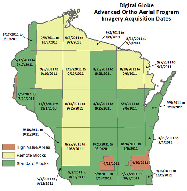
DG classifies their AOAP “region tiles” as High Value Area, Standard Block, and Remote Block. (See graphic below) Only High Value Areas are guaranteed leaf-off coverage, while leaf-off is desired, but not guaranteed, in Standard Block tiles. Leaf-off imagery is not available in Remote Block tiles. Likewise, the accuracy specifications, sun angle, cloud coverage, and haze thresholds become progressively less stringent in the Standard and Remote tiles.
As the graphic below illustrates, most of Wisconsin was acquired during the summer of 2011. Madison and Milwaukee were collected in the late spring of 2011, which should yield at least partial leaf-off conditions. Imagery is available for purchase by 1 degree x 1 degree blocks, or by smaller tiles in the case of High Value Areas.
All imagery collected by Microsoft will be displayed in their Bing Maps services, while DG is acting as the primary distributor of GeoTIFF-format products for the geospatial community.
The road ahead?
What does this mean for “traditional” aerial imagery programs in Wisconsin? In my opinion, programs like AOAP will give customers additional options to consider when selecting imagery– and having more options is a good thing. But this new development will likely require mappers in the state to even more carefully explain the differences between the national AOAP program in the context of, for example, county-sponsored projects having more stringent specifications and predictable delivery schedules.
Many government leaders will likely wonder out loud why we “just didn’t work with Microsoft” when it comes time to contract for and fund the next round of high-accuracy, high-resolution projects that have typically occurred every five years in Wisconsin.
The reality is, Microsoft and DG are currently operating AOAP strictly as a 1-foot program with no options for buy-ups to 3-inch or 6-inch imagery. That leaves many municipalities out of the picture, and a fair number of urbanized counties as well. Likewise, the client has no options for choosing leaf-off or leaf-on imagery– you purchase what they have on the shelf and ready to go.
While the imagery acquisition landscape is changing quickly thanks to programs like AOAP, educating leaders, administrators, and the people that otherwise control the proverbial purse strings, will become even more important in the future.

