In a previous Bulletin article we introduced our “virtual parcel data integration” project, the goal of which is to investigate using county Web map services to produce a statewide view of parcel data.
Over the past month we have been outreaching to county LIOs and gathering information on the Web services available in each county in the state. We greatly appreciate the endorsement of the LION Board and the assistance of the LION President (Jeff DuMez) with this effort. We have given brief overviews of the project to several organizations, including LION, WCSA (Wisconsin County Surveyor’s Association) and WIGICC (Wisconsin Geographic Information Coordination Council).
The overall goal of our project is to examine the feasibility of using Web map services to create a statewide view of parcel data collected and maintained at the county level. In other words, if a county publishes parcel data to a public web site, our project investigates ways to combine that online parcel data with similar data from other counties. The focus of our project is on parcel data but there is a broader purpose, namely to explore how Web map services can be used to support “virtual data integration” for simple mapping and display.
Unlike more traditional integration projects, we do not require counties to supply a digital copy of their parcel dataset. Instead, we make use of services that have already been published online. As such there is no stitching, edgematching or rubbersheeting involved, and data do not need to be converted to a common attribute model.
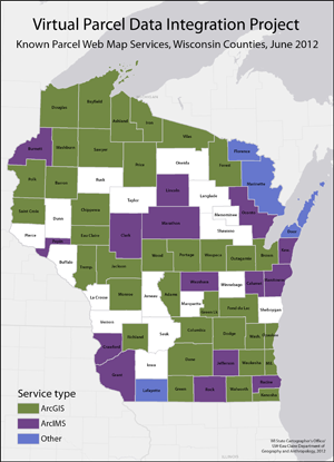
The status map accompanying this article gives a snapshot of current knowledge of parcel Web map services delivered by counties throughout the state. As the map shows, most services are based on Esri’s ArcGIS Server technology, although the specific ways these services are configured can vary significantly from county to county. The map also shows that ArcIMS services are still widely used, although in many instances counties have indicated that they are migrating to ArcGIS Server given Esri’s deprecation plans for ArcIMS. A small number of counties use non-Esri technology, including open source software providing Web Map Service (WMS) capabilities.
Blank counties on the map are cases where we are still working to discover whether Web parcel services are available. In a small number of instances, these are counties that do not yet have the capability to publish parcel data online. We will update this map as we fill in the blank areas.
The next step in the project is to investigate the capabilities and limitations of the virtual integration method. We know, for example, that we can resymbolize parcel linework so that counties look more consistent. We also know we can set the zoom levels (map scales) at which parcel data is displayed. One unknown is how easily we can overcome the limitation on querying and analysis given that the data models and attributes from different counties are not necessarily consistent. There may also be some value in analyzing how services are configured, with the ultimate goal of identifying some best practices or standards to simplify the integration task.
We will be making more results available as we move forward on our project. Please contact us if any of this information appears to be incorrect, or if you have not had the opportunity but would still like to participate. Contact information is as follows: Howard Veregin 608-262-6852; Brenda Hemstead 608-263-4371; Martin Goettl 715-836-4709.

