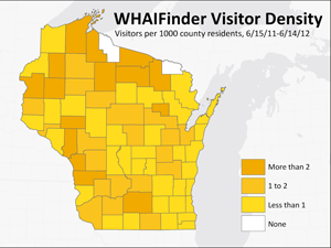
A recent study by the SCO examines the effectiveness of online maps for meeting community outreach goals. The study, which is to be published in the Auto-Carto 2012 proceedings, uses Web-usage statistics from Google Analytics for the SCO’s WHAIFinder (Wisconsin Historic Aerial Image Finder) application, which serves up scanned historic air photos of Wisconsin from the 1930s.
The SCO’s Web mapping applications, including WHAIFinder, are important technology tools that allow the office to achieve its community outreach mission. These applications evolved out of more traditional paper-based publications, maps, and catalogs over the SCO’s history. The WHAIFinder application was developed specifically to increase ease of access to the 1930s air photo collection by making it available online, with particular emphasis on providing access to parts of the state far removed from the physical photo collection in Madison. (Grant funding for the project was obtained through the Baldwin Wisconsin Idea Endowment to the SCO, the Robinson Map Library and UW Digital Collections Center). As such, ensuring wide public access to the air photo collection is essential to the success of the project. The SCO study represents an effort to quantify whether this goal is actually being realized.
The most basic question examined in the study is whether WHAIFinder usage, as measured by the number of unique visitors (derived from Google Analytics data), is correlated to population at the local level. Results show that this correlation is positive and relatively strong, lending support to the idea that the application is reaching all areas of the state approximately equally. Northern areas of the state, which are farthest from the physical collection in Madison, have some of the highest usage rates.
The study also uses statistics on Broadband access from the National Broadband Map (NBM) initiative to assess the impacts of high-speed Internet access on WHAIFinder usage. Results show that access to Broadband exerts only a minor effect on the basic relationship between WHAIFinder visitors and population. Likewise, physical distance does not exhibit a significant correlation with visitor density.
Overall, for a one-year period between June 2011 and June 2012, the WHAIFinder application generated 21,109 pageviews and 16,497 visits. The number of unique visitors over the year was 9725, equivalent to approximately 27 visitors per day or about 0.17% of Wisconsin’s population.
Studies like this are a cost-effective way for organizations to assess the effectiveness of data and information delivery. Such assessments are especially important in an era of shrinking budgets and tightening resources, in order to evaluate ROI and identify where information outreach is successful and where it can be improved. Analysis of Web-usage statistics allows for quantification, statistical analysis, and mapping, rather than just anecdotal evaluation. As such the information can be used to set outreach and information dissemination goals (e.g., reaching a certain percentage of the community) and help assess whether such goals are being met.
For more details please download the full report.

