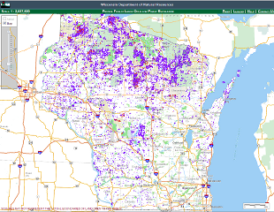
Yesterday, in a press release, Governor Scott Walker announced the availability of a new statewide mapping application to help outdoor enthusiasts locate over a million acres of private land that is potentially available for public access under Wisconsin’s Managed Forest Law (MFL) tax status.
The application comes in response to investigative reporting by the Milwaukee Journal Sentinel which concluded that while these lands are open to public access in concept, locating the properties was difficult at best.
The Wisconsin Department of Natural Resources took up the challenge and developed the new application in just over a month, leveraging their long history with geospatial technology and interactive mapping development. While a more comprehensive application is foreshadowed to be in the works, the MFL Open Lands application is a great example of how statewide mapping efforts can help visually answer complicated questions and improve citizen services statewide.
To access the mapping tool which also includes lands enrolled under the Forest Crop Law, visit the DNR website here.
On the DNR webmap’s Help page, we find additional information on the map content under the Introduction:
This Private Forest Lands Open for Public Recreation web mapping application is designed to give you an easy way to view the APPROXIMATE representations of lands enrolled in the Managed Forest Law (MFL) and Forest Crop Law (FCL) programs that are “Open” to public recreation. Land enrolled in MFL are designated as “Open” or “Closed” to public recreation. The “Open” designation allows public access (for select activities) to the property without additional permission from landowner(s). The “Closed” designation affords landowners the right to restrict or permit access. All land enrolled in FCL is open to public access (for select activities) without additional permission from the landowner(s).
ONLY APPROXIMATE representations of “Open” lands are displayed in this application. This application will display land enrolled in the tax law program down to the quarter-quarter section of the public land survey (approximately 40 acres in most areas). If enrolled land is smaller than the quarter-quarter section, you will need to talk to the landowner or the DNR Forester to find out where in the quarter-quarter section the “Open” land is located. County Plat books are also a good source of ownership information. They may be available at public libraries, the county clerk’s office, or you can purchase them directly from the plat book publisher.
Go to the Managed Forest Law web site for further information about the tax law program.
http://dnr.wi.gov/topic/forestlandowners/tax.html
Additional information on the availability of plat books in Wisconsin can also be found here:
http://www.sco.wisc.edu/find-maps/platbooks-and-land-ownership.html

