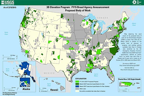
The US Geological Survey (USGS) National Geospatial Program has announced the first round of awards resulting from the Broad Area Announcement (BAA) for the 3D Elevation Program (3DEP) issued in July 2014. Details of the BAA were provided in an earlier Wisconsin Mapping Bulletin article.
The USGS awards will provide partnership funds to offset LiDAR acquisition costs for 29 projects in 26 states and territories. The projects are expected to result in more than 95,000 square miles of public domain LiDAR point cloud data and derived elevation products.
Three projects were awarded in Wisconsin:
- Lincoln County Land Services (905 sq. miles). New LiDAR data planned for spring 2015. Acquisition via USGS Geospatial Products and Services Contract.
- Oneida County Land Information (Oneida and Vilas Counties, 2250 sq. miles). Cooperative Agreemen to obtain LiDAR acquired by counties in 2013. Funding provided to procure source data and incorporate into 3DEP.
- Wisconsin Coastal Management Program (2525 sq. miles). Cooperative Agreement with Douglas, Bayfield and Manitowoc Counties. Cost share funding to acquire new LiDAR in spring 2015. Acquisition via Wisconsin Regional Orthophotography Consortium (WROC) contractors. Additional partners including FEMA with separate contracts for Ashland and Marinette Counties.
For more information see the USGS press release. Further details on the Wisconsin projects will be provided in the Mapping Bulletin once these details are made public.

