In early December last year we announced the addition of the Wisconsin Coordinate References Systems (WISCRS) to the international EPSG Geodetic Parameters Registry. Users of several popular open source packages can now utilize the WISCRS EPSG codes by downloading new parameter files. Thanks are due to Even Roualt from Spatialys for updating the necessary parameters from the latest EPSG database.
The standard disclaimer applies, always make a backup copy of files before you overwrite them! The following procedures worked fine for me, but you’ve been warned.
Geospatial Data Abstraction Library (GDAL)
GDAL is a translator library for raster and vector geospatial data formats that can be used “standalone” for data manipulations, or integrated into Java, Python, C, C++, Ruby, and R applications.
To update GDAL, several files must be downloaded from the GDAL source on Github, and copied to the right place in your GDAL install. Depending on your platform (Windows, OSX, Linux) and method used to install, that location varies: typically .\gdal\gdal-data, or .\share\gdal. (Hint: try searching for pcs.csv to find the right spot.)
For your convenience, here is a zip file containing the necessary updates:
gdal_data.zip![]() 266.84 KB (downloaded from GDAL source on 1/22/2016)
266.84 KB (downloaded from GDAL source on 1/22/2016)
PROJ.4 Cartographic Projections Library
PROJ.4 is a map projection engine used by software developers. It simplies the advanced coding and mathematics otherwise needed to handle coordinate system conversions. As with GDAL, the location of the file containing the parameters can vary, but look for a text file (no extension) called “epsg,” usually located in the root of the PROJ installation folder or .\share\proj.
epsg.zip![]() 91.69 KB (downloaded from PROJ.4 source on 1/22/2016)
91.69 KB (downloaded from PROJ.4 source on 1/22/2016)
Extra steps for QGIS Users
Learning how to update the popular QGIS desktop software to take advantage of the new EPSG codes turned into an adventure I wasn’t expecting. Through a lot of creative Googling and reading through a variety of forums, I determined the process involves two steps: first update the installation of GDAL on your system, and then run an executable to sync those updates to an internal QGIS coordinate parameters database.
Because there are a variety of methods to install QGIS, it’s difficult to provide step-by-step instructions for every scenario.
One popular method of installing both QGIS and GDAL is through OSGeo4W. If you used this method, grab the gdal_data.zip file above, and copy the unzipped contents to .\share\gdal.
Then, open a Windows command prompt, and navigate to \OSGeo4W64\apps\qgis\ (or \OSGeo4W\apps\qgis if you installed the 32 bit version). You should see a program called “crssync.” On my system, I received a missing DLL error when attempting to run cryssync.exe the first time, so I switched into the “bin” subfolder, and ran “..\crssync.exe”. That worked fine in my case.
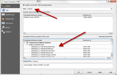
It seems normal for crssync to spit out a few errors during the update, but you should see something on order of 830 CRSs updated, depending upon which version of QGIS you are using. Fire up QGIS, and confirm you see the WISCRS parameters.
For Mac users, the process is conceptually the same, except the contents of gdal_data.zip should be unpacked here:
/library/frameworks/GDAL.framework/Resources/gdal/
then, switch to the following folder in a terminal window, and run “sudo ./crssync”:
/applications/qgis.app/Contents/MacOS/lib/qgis
If you run into problems with this process in QGIS, drop me a line.

