
The Wisconsin Office of Emergency Communications has announced that the Wisconsin Next Generation 9-1-1 (NG9-1-1) Status Map is now live and can be found here.
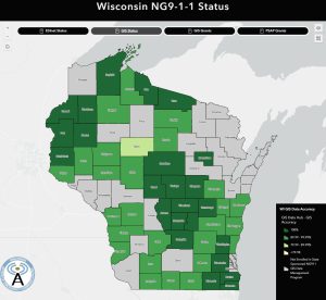
The status map has four tabs.
The first is the overall ESInet project status map. If you click on individual counties or municipalities you can get more detailed information about that entity’s status.
The second tab shows the status of the GIS data for each county’s project. This data is from the GeoComm GIS Datahub under a state GIS data management contract under the Wisconsin Next Generation 911 Project.
The last two tabs display information about whether a county received a GIS or PSAP grant in the past.
There is also a link to Office of Emergency Communications in the lower left corner of the status map. The status map will be updated on a weekly basis when new information is available.
Please reach out to Zach Hassler, GISP, at the Office of Emergency Communications with questions.