Quick Links
One of the missions of the State Cartographer’s Office (SCO) since our establishment in 1974 revolves around facilitating access to Wisconsin aerial photography. It all began in 1975 with our very first Aerial Photography Catalog. That catalog has gone through many iterations over the years, and for some time now has been available online for folks wanting to find and acquire historic photographs covering locations throughout the state.
As part of this ongoing work, in 2011 we released the Wisconsin Historic Aerial Imagery Finder (“WHAIFinder”) through a collaborative effort funded by the Ira and Ineva Reilly Baldwin Wisconsin Idea Endowment. WHAIFinder was designed to facilitate public access to the oldest set of statewide photos available, which date between 1936 and 1941. WHAIFinder has proven to be one of our most popular Web apps.
We are happy to share some updates on more recent work, all of which are the result of a longstanding partnership with a sister organization here at UW-Madison, the Arthur H. Robinson Map Library (RML).
Expanded Imagery Collections
While the WHAIFinder Web app itself has gone through at least two different technology iterations since 2011, the core imagery collection has remained unchanged: approximately 38,000 downloadable digital air photos collected between 1936 and 1941. Thanks to falling storage costs, new film scanning happening at the federal level, and the availability of new spatial indexes, we are working to dramatically increase the amount of downloadable imagery available via a forthcoming “all new” WHAIFinder Web app. As I write this, we have roughly 103,000 images in the growing RML digital imagery archive, ready for access through methods I describe below. We have another 30,000 or so images in the queue for processing over the next 4-6 months.
New Feature Service
The forthcoming WHAIFinder Web app taps into a new service GIS professionals can find in ArcGIS Online and then use in desktop GIS tools like ArcGIS Pro. We have a data dictionary available to help you understand the attributes found in the service.
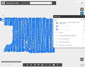
 As an example of how this can be used, staff at the Columbia County Land Information Department integrated our photo index service into their own county Web mapping app. In doing so, users of their app are able to directly download historic images from the RML archive. While an ideal solution would involve georeferencing the source imagery with control points, mosaicking, and making the result available as an imagery service, doing so requires significant effort and resources that may not be available.
Bulk Downloads
In the past, images found in WHAIFinder were only available as single downloads, or by special request to the SCO/RML team. We are now storing the entire imagery archive in an AWS S3-compatible “bucket” maintained for us by the UW-Madison Division of Information Technology (DoIT). With the right tool, you can connect to the bucket of data and download as much imagery as you like for free. We have instructions available if you would like to give this new download option a try.
Georeferenced Imagery
All of the imagery in the RML archive has at least basic georeferencing information applied. For photos scanned from prints or film, we use what I call a “simple centerpoint” method to assign map coordinates. While far from perfect, this approach usually places the photograph within a couple hundred meters of its correct spatial location. Orthorectifying or using ground control points to more accurately georeference the photographs is of course preferred, but far beyond what our resources allow.
If you grab a sample file and pull it into your desktop GIS software, you can get a sense for how this works. Because the georeferencing depends upon the accuracy of the index points used to locate the approximate geographic center of each photo, results will vary. In this example the georeferencing isn’t as good as the first, but it’s reasonably close and puts things in the ballpark.
New WHAIFinder Web App Coming Later this Fall
Our renewed emphasis on expanding the archive requires us to completely overhaul the existing WHAIFinder Web app. We are currently in the process of rebuilding it using the Esri JavaScript SDK, which is an entirely new experience for our team. I’m hesitant to predict exactly when it will be available, so I will give us some wiggle room and simply say “this fall!” Send us an e-mail if you are interested in helping us test the new version when a beta version is available.
If you have questions on any of the above resources, send an email to help@sco.wisc.edu anytime!
