Some readers may already be familiar with Bojan Savric’s May 8, 2024, blog post titled “Prepare your data for the National Spatial Reference System modernization of 2022 in the U.S.” The National Geodetic Survey (NGS) is in the process of updating the National Spatial Reference System (or NSRS) to replace NAD 83 with NATRF2022 in the continental U.S. (The vertical datum, NAVD 88, will also be replaced, but I will not discuss that here). At the SCO, we have published numerous posts of our own on NRSR modernization. Please see the WSRS2022 page for a list.
In his post, Savric, who works at Esri, advises users to transform data in historic coordinate systems (e.g., NAD83 HARN) to the latest NSRS datum and realization, that is, NAD 1983 (2011) Epoch 2010.0. Savric provides details on how to implement such transformations in Esri software. In particular, the post mentions the importance of using the NADCON 5.0 transformation grids, which requires users to install the ArcGIS Coordinate Systems Data software. Savric also notes the importance of transforming step-by-step between adjustments of NAD 83.
I recently reached out to Savric, and his colleague Melita Kennedy, with some questions about these procedures. My questions, and the responses from Savric and Kennedy, are given below. I performed some tests of the Esri transformation results, with and without the imported NADCON grids. I also compared the results to NCAT, which is the NGS’s authoritative transformation tool.
Question 1
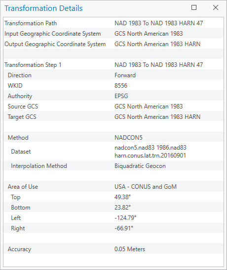
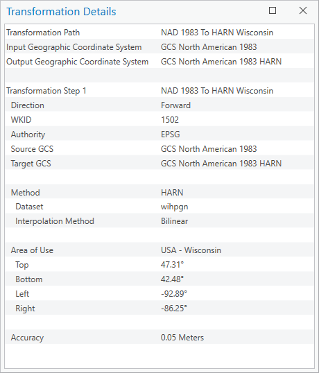
While the Esri NADCON transformations produce the same results as NCAT, other transformations available in Esri sometimes produce different results. For example, transforming the point at 45N 90W from NAD 83 (1986) to NAD 83 (HARN) using NAD_1983_To_HARN_Wisconsin yields transformed values of 45.000,000,217,2, -89.999,998,278,9, while using NAD_1983_To_NAD_1983_HARN_47 (the NADCON transformation) yields values of 45.000,000,346,2, -89.999,998,316,3. The latter are the same as NCAT. The differences between the Esri transformation tools are on the order of centimeters. Am I correct that different transformations produce different results?
Answer 1
That is correct. Each transformation is using a different method and different grid file which produce different results. NAD_1983_To_HARN_Wisconsin is an old/original transformation, which NGS replaced with the NADCON grid. Even though both have equal estimated accuracy, the current NAD_1983_To_NAD_1983_HARN_47 should be used.
Note that the original NAD 1983 to NAD 1983 (HARN) grid files were done piecemeal as the surveying was completed. They extend well beyond the state borders and the overlaps were not reconciled or revised as neighboring states were completed. For NADCON5, NGS created a countrywide file but did not try to make it conform with the original state-based files, different results are likely. For states that had a second (or third HARN) re-adjustment, NGS now calls those the FBN and there’s a separate NADCON transformation from NAD 1983 (HARN) to NAD 1983 (FBN).


Question 2
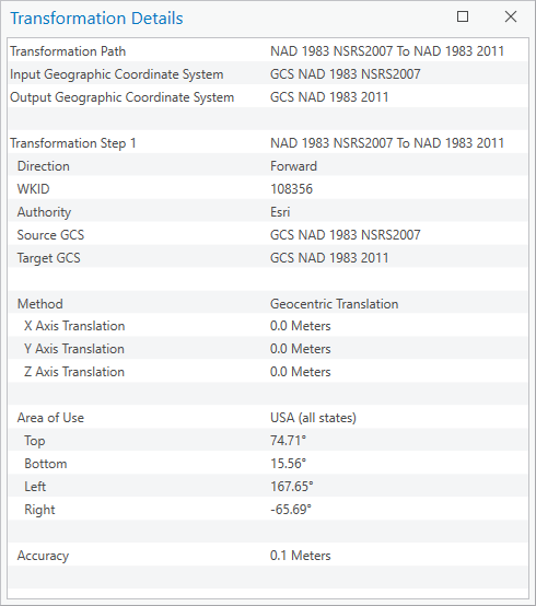
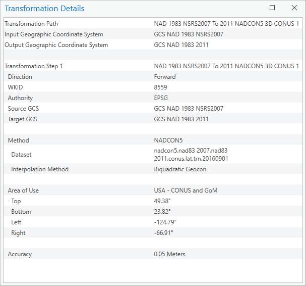
In some cases, older Esri transformations do not seem to change coordinate values at all. For example, if I transform 45.000,000,217,2 , -89.999,998,278,9 in NAD 83 (2007) to NAD 83 (2011) using NAD_1983_NSRS2007_To_NAD_1983_2011, the coordinates do not change. But if I use NAD_1983_NSRS2007_To_2011_NADCON5_3D_CONUS_1, I get 45.000,000,514,6, -89.999,998,316,4 (again, several centimeters different). I’m wondering why the coordinates do not change when I use NAD_1983_NSRS2007_To_NAD_1983_2011.
Answer 2
If you use NAD_1983_NSRS2007_To_NAD_1983_2011 then coordinates will not change. The reason for this is because NAD_1983_NSRS2007_To_NAD_1983_2011 is a so-called “null” transformation, treating NAD 1983 (NSRS 2007) and NAD 1983 (2011) to be equivalent systems. This transformation can be utilized for “less accurate GIS” work or simply for display purposes. Looking at the transformation details, you can see that the transformation is less accurate compared to NAD_1983_NSRS2007_To_2011_NADCON5_3D_CONUS_1.


Question 3
What guidance can Esri provide to users who are faced with multiple transformation methods that produce different results? There are hundreds of transformations involving NAD 83 in the Esri list of supported transformations. How is a user to know which one(s) to use? For example, I would assume many Wisconsin users would believe that transformations with the name “Wisconsin” in the title (e.g., NAD_1983_To_HARN_Wisconsin) are the appropriate ones to use for Wisconsin data. However, this would appear not to be the case. Even more critical, perhaps, what should the response be to users who have, over the past few decades, transformed their data to NAD 83 (2011) using the Esri transformations, and may not longer have the original NAD 83 (1986) data available? What should they do now?
Answer 3
This issue was one of the reasons that we published the NSRS2022 blog post to give direct guidance on which transformations to use. Esri has many transformations between NAD 83 re-adjustments. This is due to several transformations being released by NGS and other mapping agencies across the country over the past 30 years. We keep all available for various reasons, including backwards capabilities and revertabilities. Some transformations are also result of hundreds of odd workflows users perform in ArcGIS and for those, these are applicable.
Particularly for HARN, NSRS2007, and 2011 re-adjustments, in many places the offsets were quite small. If someone has environmental data, the data accuracy may not be high enough to warrant transforming with NADCON-based transformations. In more generic recommendations, we would advise users to always check the transformation details window to see what transformation path they picked and the accuracies of individual transformation steps. In general, try to pick the best available option (highest accuracy, that is lowest accuracy value).
Since our algorithm relies on all available options, we would not recommend using any transformation paths that transform via WGS 1984 systems since those are unrelated and inaccurate for NAD 83, but still relevant and needed for conversions to/from WGS 1984.
As for the users who have transformed their datasets in the past and lost their originals, if their data in NAD 83 (2011) aligns well with other existing datasets and all is within the expected accuracy, they should be okay. If they see discrepancies that are not acceptable, then they should retrace their steps back to the original NAD 83 data. Most of these transformations are still available in ArcGIS exactly for this reason. They may just be listed further down on the options list. Of course, this is only possible if users know what steps they took.
