
Wisconsin is one of several states bisected by the 45th north parallel, the line of latitude marking the “half way point” between the Equator (at 0 degrees latitude) and the North Pole (at 90 degrees north latitude). The other states are Oregon, Idaho, South Dakota, Minnesota, Michigan, New Hampshire and Maine. In addition, the boundary between Montana and Wyoming roughly follows the 45th parallel, while portions of the Canadian border for New York, Vermont and New Hampshire also straddle this line.
There are several markers in Wisconsin that claim to be on the 45th parallel. The most well known of these is the “Poniatowski Marker” in Marathon County, which is purportedly “exactly halfway between the North Pole and the Equator.”
Another marker, shown in the photograph, is in southern Marinette County, off Highway 41, just north of the Marinette-Oconto county line. The marker was set in 1938 by Frank E. Noyes, publisher of the Marinette Eagle.
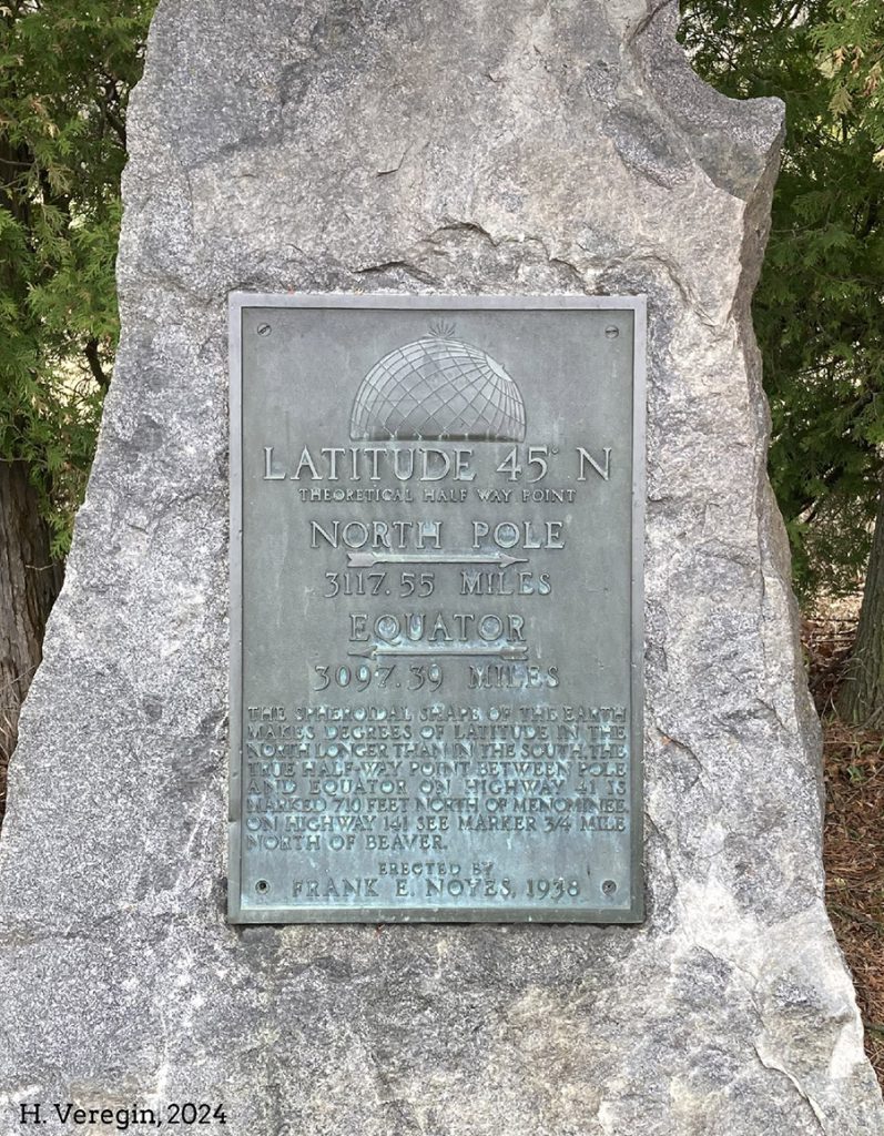
The details on the marker are a bit confusing. It states that it is located at Latitude 45 North, the “theoretical half way point” between the North Pole and the Equator, but then notes that the North Pole is 3,117.55 miles to the north while the Equator is only 3,097.39 miles to the south. Not exactly half way.
The marker explains that, due to the spheroidal shape of the earth, lines of latitude are not equally spaced, and that the “true” half way point is at another marker just north of the community of Beaver on Highway 141.
The Highway 141 marker (also placed by Noyes in 1938) indicates that it is equally spaced 3,107.47 miles between the Equator and the North Pole, and that its latitude is 45 degrees, 8 minutes, 45.7 seconds north.
I’m confused. What’s going on?
The source of the confusion, as Noyes correctly states on the Highway 41 marker, is that the earth is spheroidal (or ellipsoidal) in shape. In other words, it is not a perfect sphere. If it was, then 45 degrees north would also be the half way point in terms of distance. But the earth is compressed along its polar axis and bulges out at the Equator. It is known as an “oblate ellipsoid.”
Today, the equatorial radius of this oblate ellipsoid is usually given as 6,378.14 km (3,963.19 miles) and the polar radius as 6,356.75 km (3,949.90 miles). The ratio [(equatorial radius – polar radius ) / equatorial radius] gives a “flattening” value of about 0.003 353.
The latitude (or more precisely, the geodetic latitude) of any point is formed by the “normal” to the earth’s surface (i.e., a line 90 degrees to the tangent to the surface at the selected point). This line does not usually pass through the center of the earth, as it would if the earth were truly a sphere.
To make matters a bit more complicated, the latitude is not actually measured at the earth’s surface, with its bumps, depressions, hills and valleys, but relative to a mathematical ellipsoid model that “best represents” the overall shape of the earth in a generalized way.
As a result, lines of latitude are not evenly spaced as they march north from the Equator. Instead, they get further apart. At 20 degrees North, a degree of latitude is about 110,704.3 m (68.8 miles), while at 70 degrees North, a degree of latitude is about 111,562.0 m (69.3 miles). The distance from the Equator to 45 degrees north is about 4,984.95 km (3,097.50 mi) while the distance from 45 degrees north to the North Pole is 5,107.02 km (3,117.43 miles). These numbers, computed using a finite approximation, correspond pretty closely to values of 3,097.39 and 3,117.55 miles on Noyes’ Highway 41 marker.
Pretty close? Why aren’t they exactly the same?
Geodesists, scientists who are concerned with the size and shape of the earth, are constantly revising the ellipsoid model used to represent the generalized shape of the earth. In 1938, when the marker was set by Noyes, most geodesists were probably using the Clarke Ellipsoid of 1866. This ellipsoid has an equatorial radius of 6,378.21 km (3,963.23 miles) and a polar radius of about 6,356.58 km (3,949.80 miles). The flattening value is 0.003 390.
These numbers are slightly different than the modern values given above in the discussion of the oblate ellipsoid. That’s because the ellipsoid model used today, called WGS 84, is not the same as the Clarke 1866 model. The Clarke ellipsoid is a little flatter, pole-to-pole, than WGS 84.
WGS 84 is the ellipsoid used by GPS and the US military. It is considered more accurate than the older Clarke 1866 ellipsoid. But to make matters slightly more complicated, WGS 84 is not the only ellipsoid in use today. In fact, there are dozens of others, some tailored to specific locations and others for world-wide use. One of these ellipsoids, called GRS 80, is used by the US federal government for civilian mapping, and is the ellipsoid model underlying the North American Datum of 1983 or NAD 83.
If we use the Clarke 1866 ellipsoid in our finite approximation for the Highway 41 marker, we get distances that are much closer matches to the values inscribed on the marker.
I’m glad that’s over
Not so fast. There’s another problem. It is not widely appreciated that the precise latitude (and longitude) of a given feature on the earth is not unique. In other words, the latitude can vary depending on which ellipsoid is used. This explains another interesting fact, which is that the Highway 41 marker is not actually at 45 degrees north, at least not according to WGS 84. According to this ellipsoid, the 45th parallel has moved north relative to its location on the Clarke 1866 ellipsoid. This puts the marker about 125 meters (410 feet) short (i.e., south) of 45 degrees. So, the distance from the marker to the Equator is probably more like 4,984.82 km (3,097.42 miles).
There’s more. Remember that marker north of Beaver on Highway 141? The marker gives its location as 45 degrees, 8 minutes, 45.7 seconds north. Assuming that’s true (at least based on the Clarke 1866 ellipsoid) then the distances from the marker to the Equator and North Pole are, in fact, almost identical. However, since we know that the Clarke 1866 ellipsoid does not give the same latitude as the WGS 84 ellipsoid, it’s likely that this marker is a bit closer to the equator than the numbers suggest.
Are we done?
Not quite. One problem we haven’t addressed is the fact that the location of these markers is going to shift again when the new NATRF 2022 reference frame is implemented (maybe as early as next year). NATRF 2022 will replace the NAD 83 system, which relies on the GRS 80 ellipsoid. Although NATRF 2022 will also use the GRS 80 ellipsoid, it will be translated and rotated from its position on NAD 83 to make it better earth-centered and better aligned to earth’s spin axis. As a result, the latitude and longitude of every point will also shift. In Wisconsin, this shift will be between 1 and 1.5 meters (3 to 4.5 feet).
And there’s one important thing we haven’t mentioned yet. We need to remember that, as a result of plate tectonics, all locations on the earth are also physically moving. This is not just a shift in the ellipsoid, but an actual, physical change in location. Wisconsin, which sits on the North American Plate, is rotating counter-clockwise at a rate of a few centimeters (about an inch) per year. This means that back in 1938, when Noyes set his monuments, they were actually about 2 meters (6 feet) roughly east of where they are now.
Tectonic plate movement is accounted for in the new NATRF 2022 model, such that every latitude-longitude value will have to be corrected for plate rotation to take it back to where the point would have been at the start of some defined “epoch.” Otherwise, for very precise measurements required for things like engineering and self-driving vehicles, coordinates would gradually become out-of-synch. Locations on the earth’s surface are not two-dimensional (latitude-longitude) but three-dimensional (latitude-longitude-time).
This sort of makes me lose confidence in cartography
Most of these changes are too small to be seen on the map you use to get to the nearest Starbucks. But they do have implications for precise measurements. And if you happen to see a roadside marker advertising its precise geographical location, remember to treat it with some skepticism. Even if we could decide on a final ellipsoid model once and for all, because of plate tectonic movement, no fixed location, sign, plaque or monument can ever claim to be “exactly halfway between the North Pole and the Equator.”