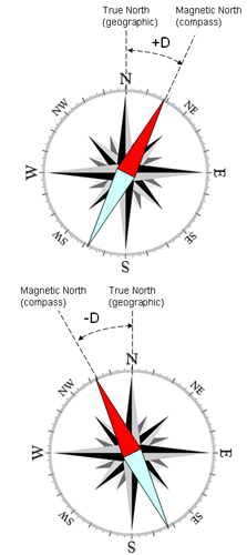
The angular difference between the geographic and the magnetic meridians at a point on the earth is called magnetic declination. The values for magnetic declination in Wisconsin vary today from -4.0° in Door County to +1.5° in the west-central part of the state. While these values are not as great as the +20° declination in Seattle, Washington, they are still of concern to surveyors, map makers and navigators, and others who use maps or compasses.
Using Magnetic Declination
The line of 0° declination currently passes through Wisconsin. Keep in mind that when you are located west of the 0° line-of-declination, the declination is east (or positive). When located east of the 0° line, the declination is west (or negative).
To translate the difference between the geographic and magnetic meridian, the angle of declination must be subtracted from the magnetic north reading. For example, Eau Claire, located west of the 0° line, has a magnetic declination of approximately 1° 30′ east (as of 1998). To correct a magnetic compass reading to true north when west of the 0° line, the declination value should be subtracted from the magnetic north reading. When east of the 0° line, you should also subtract the declination from the magnetic north reading, but remember that in this case the declination value is negative. Subtracting a negative number will essentially result in adding the declination value to the magnetic north reading. Where the magnetic declination is zero, a compass needle will point true north.
Magnetic Deviation
 Courtesy of www.magnetic-declination.com
Globally, the magnetic field lines (which make up the magnetic meridian) are similar to the lines of longitude which form the geographic meridian. That is, they encircle the globe and converge at a common point in each hemisphere. The true magnetic pole in the northern hemisphere presently lies in the Northwest Territories, Canada. It is about 11.6° south of the geographic north pole, and about 104.3° west longitude. On a more detailed level however, the magnetic lines are not straight, but bend and arc depending on local magnetic conditions. This bending is called deviation.
Magnetic Variation
Another factor that alters the value of magnetic declination is called variation, which occurs over long periods of time. Due to the dynamic nature of the earth’s interior, the magnetic field is constantly changing. This causes “drift” of magnetic north and oscillations of the magnetic meridian. This change in magnetic declination is called annual change (also secular variation). It follows trends in the short term, but is very unpredictable in the long term. Lines of annual change in Wisconsin now drift about 6.5′ west each year. In a year the 0° line will have moved 6.5′ west and by the following year it will be approximately 13′ west. (6.5′ of westerly shift in Wisconsin is approximately 11 miles).
Calculating Magnetic Declination
Using the Internet, you can now determine magnetic declination for any place on the earth since 1900. The National Geophysical Data Center (NGDC) offers programs for calculating magnetic declination.
To view a simpler graphical reference, the U.S. Geological Survey started a National Geomagnetism Program that produces maps and guides explaining the magnetic declination and annual change. The maps are revised every five years or so to compensate for the changes in the magnetic field.
Related Links and Resources
-
- Search and Rescue Society of British Columbia provides a complete listing of informative map and compass links.
- Finding your way with map and compass, provided by the USGS, is a short and informative guide to using a compass in the field.
- Many books on the subject of orienteering or navigating with a compass can be ordered on the Internet. Your local bookstore or camping outfitter is also likely to carry books on the subject.
