A one-day forum entitled This Land Is Your Land was held at the Lafayette County Multipurpose Building in Darlington on April 18, 2019. The forum — free to all attendees — was the 5th annual forum following events in Stevens Point (2015), Eau Claire (2016), Wisconsin Dells (2017) and Rothschild (2018).
The overall goals of these forums are to educate county officials, professionals, and the general public about the Public Land Surveying System (PLSS), to facilitate dialog about the importance of PLSS for accurate parcel mapping, and to bring the GIS and Surveying communities together to identify and discuss common interests.
The 2019 forum attracted 120 people with a variety of professional occupations and affiliations, including 41 county employees and 11 County Board members.
The Public Land Survey System
The PLSS serves as the cornerstone of all property descriptions in the Wisconsin. Established in the 18th century to facilitate land conveyance from the federal government, the PLSS requires continued maintenance to ensure accurate depiction of land ownership. Without a properly maintained network of PLSS corner monuments, there is an increased risk of property disputes, inequitable taxation, disagreements about resource rights, confusion over easement locations, and unnecessary expenditures by private citizens and local governments.

The 2019 PLSS Forum focused on the following topics:
- The importance of PLSS as the foundation of property ownership determination in the state
- The role of accurate PLSS information for correctly depicting parcel boundaries
- The importance of maintaining and investing in the PLSS network
- The role of the County Surveyor in PLSS maintenance
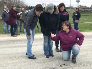
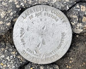
An important aspect of the forums since the 2017 event in Wisconsin Dells is a short field trip to an original PLSS corner monument. This year, the monument was a quarter-section corner quite literally in the middle of County Shop Road.
Forum Resources
A final report on the forum is now available. In addition, PDFs of the talks given at the Forum have been posted online:
- Introduction/Overview (Howard Veregin, State Cartographer)
- The Public Land Survey System: A Dependable Network for Land Ownership (Bryan Meyer, La Crosse County Surveyor)
- Role of the County Surveyor (Doug Avoles & Laurence Johns, Vernon County)
- Breakout Session: Research Methods (Dan Frick, Dane County Surveyor)
- Boundaries and Easements (Larry Austin, Professional Land Surveyor & Engineer/Retired Professor, UW Platteville)
- Property Surveys and Legal Descriptions (Bryan Meyer, La Crosse County Surveyor & Brannick Beatse, RPL)
Acknowledgements
The forum was organized by the PLSS Work Group a diverse group of organizations and individuals formed to advocate for PLSS in Wisconsin.
The forum was hosted by the Lafayette County Land Information Program including Lauree Aulik, Krista Paulson and Aaron Austin. Lunch was sponsored by the Wisconsin Society of Land Surveyors. Refreshments were provided by the Wisconsin County Surveyors Association and by Jason Poser, Buffalo County.
The PLSS Work Group would like to thank our hosts, sponsors and speakers for making this event a success!
PLSS Work Group Position Statement
The PLSS Work Group advocates for the following position:
The PLSS network in Wisconsin can and should be fully re-established. But the work will require the expertise of Professional Land Surveyors and funding. Each of Wisconsin’s 72 Counties should have a County Surveyor on staff to oversee the remonumentation and maintenance work. The County Surveyor can serve as an advisor to taxpayers, property owners and/or their private sector land surveyors within each county regarding PLSS concerns. To that end, we believe the following to be critically important.
- An accurate, complete, up-to-date county PLSS network can and should be in place in every county in Wisconsin.
- Counties should make funding a County Surveyor position a priority and provide this individual with the resources needed to do the work of re-establishing and maintaining PLSS corners.
- Counties should fund PLSS remonumentation and maintenance on a consistent, predictable basis.
- Once PLSS corners are re-established, maintenance of those corners should be an ongoing priority.
- Counties should work with neighboring counties to resolve discrepancies in PLSS corner locations so that county boundaries fit together seamlessly.
- Counties have a great resource available to them in the Wisconsin County Surveyors Association. This group can share the importance of the PLSS by giving presentations or talks to County Boards and Committees.
- Counties should not defund existing County Surveyor positions or withhold funding for maintenance of PLSS based on an existing plan.
For more information on the PLSS Work Group visit the group’s webpage.


