A change in the Low Water Datum (LWD) for the Great Lakes is being considered due to changing water levels in the basin. A new LWD could be released as early as 2027. This change is part of a larger update to the International Great Lakes Datum (IGLD), being led by the US-Canada Coordinating Committee on Great Lakes Basic Hydraulic and Hydrologic Data.
The LWD is the depth below which water levels seldom fall. One of its primary uses is for navigation, to ensure sufficient depths of water in navigation channels even when lake water levels are low. Each lake in the Great Lakes system, as well as their connecting channels, have their own LWD surface.
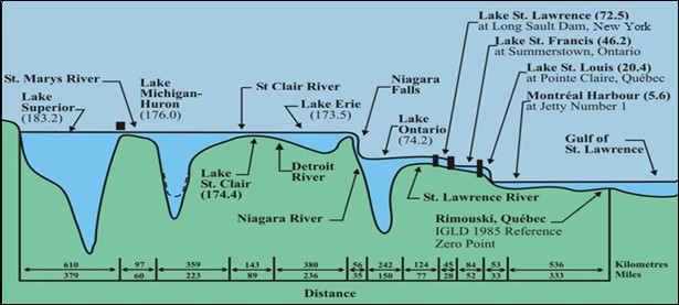
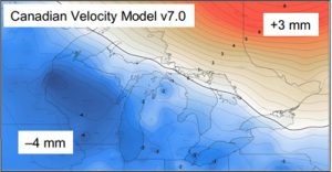
The Great Lakes LWD was established in 1933. Since that time, lake levels have changed due to new engineering projects (locks and dams) as well as physical changes, most notably Glacial Isostatic Adjustment (GIA). GIA refers to changes in land surface elevation in response to the melting and retreat of continental glaciers. While this melting occurred thousands of years ago, its effects are still being felt in the Great Lakes basin. In Wisconsin, for example, land is subsiding as much as 4 mm per year, due to the fact that Wisconsin is a “collapsing peripheral fore-bulge” where the earth’s mantle is slowly flowing in a northeasterly direction.
As a result of these changes, the LWD on many of the lakes no longer reflects the low probability threshold it is intended to. Also, the LWD has a different statistical meaning on different lakes. For example, for Lakes Superior, Michigan and Huron, observations over the last century show that over 15% of all months have a low water level that is below the LWD. The percentages for Lake Erie and Ontario are much lower, less than 5%, with no dips below the LWD at all since 1965.
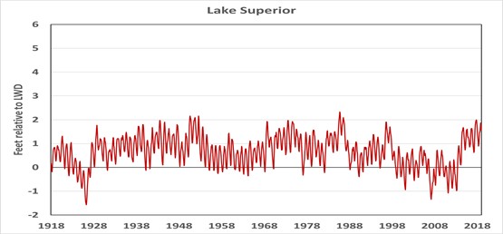
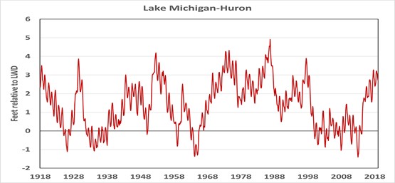
Water levels in Lakes Michigan and Huron over time (source: Beach et al., 2023)
To eliminate these problems, the Coordinating Committee is considering updating the LWD. The procedure would involve using historical water level data to determine an appropriate “exceedance probability.” For Lakes Superior and Michigan, the result could be a lowering of the LWD by a foot or more, depending on the exceedance level selected.
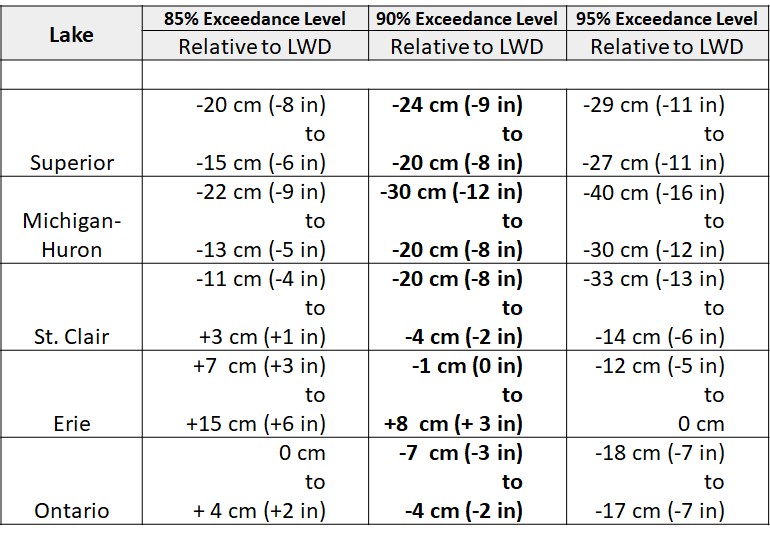
Such a change would have effects rippling through many areas. Maps and charts would need to be updated, software conversion tools would be required, and metadata would become even more important to ensure the proper datum is referenced. One of the most significant effects would be on maintenance of navigation channels. The US Army Corps of Engineers (USACE) is responsible for dredging of federal navigation channels. Different channels have different authorized depths below the LWD that must be kept clear for navigation. A new LWD means additional dredging will need to occur.
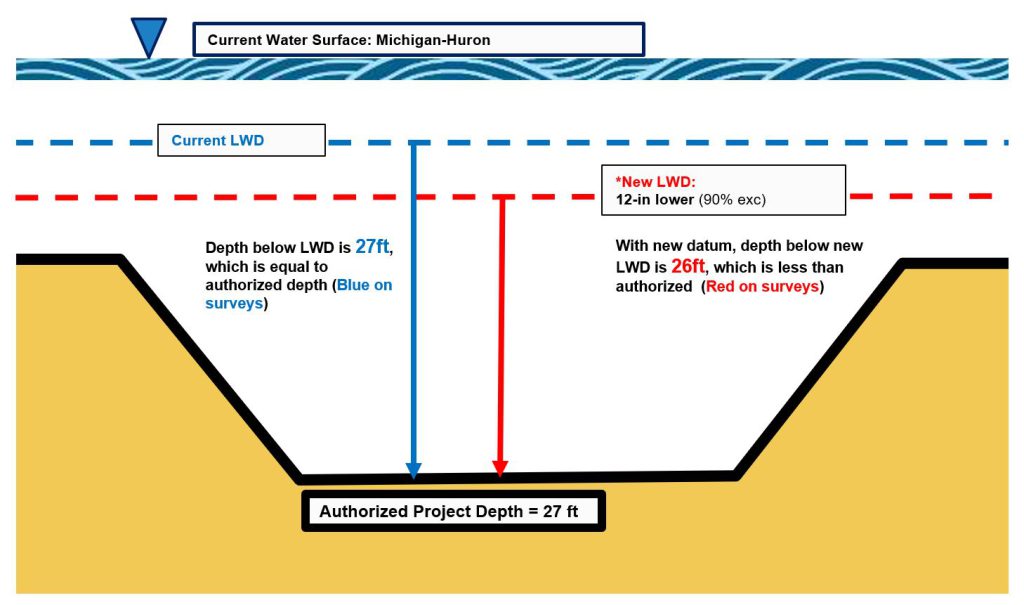
The volume of additional material that will need to be dredged is enormous — on the order of millions of cubic yards — with a total cost in the hundreds of millions of dollars. In addition, there are issues associated with removal of hard bottom channel material (e.g., bedrock), lack of placement sites, and environmental compliance.
At this time, the implications of a change to the LWD are being studied by the Coordinating Committee, alongside the larger IGLD (2020) update, which will have even broader effects since it will redefine the base level for all elevations in the system. IGLD (2020) is planned for release in 2026, about one year after the release of the NAPGD2022 vertical datum.
For additional details, the Coordinating Committee has an excellent collection of materials on this topic. The main resources used for this article were the LWD Fact Sheet and the following PowerPoints (available on the Coordinating Committee website):
LWD: An Introduction by Derrick Beach, Laura Rear McLaughlin, Chris Zervas and Terese Herron
Impacts on Channel Maintenance by Esther Johnson, Cindy Jarema, Jennifer Marche and Joffrey Dufour
IGLD: An Introduction by Jacob Heck and Michael Craymer
